
Coastal
& Ocean | Internet Services
| GIS
& Database Services
 Coastal
Projects
Coastal
Projects
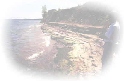
Coastal Data Portal, Grays Harbor
County, Washington – Working with
Pacific International
Engineering and
Pangaea
Information Technologies, CJS assisted in the development of a
web-based information management system that will allow access to complex
scientific data, reports, and mapping by members of the Washington State
Coastal Communities, and other interest groups along the Washington State
shoreline. Visit the portal web site at:
www.washington-coastal.com
Summary of Existing Land Use, Land Use Trends and
Shoreline Land Use Management Policies Along the Lake Ontario – St.
Lawrence River Shoreline: Implications for Future Water Level Management.
CJS was responsible for a review and analysis of the existing land use
situation along the shoreline of Lake Ontario and the St. Lawrence River,
as well as an examination of trends in land use and residential
development that have been occurring over the last ten years and that
reasonably may occur into the future. Existing shoreline management
and land use development practices and policies that are in place in both
Ontario and New York State were also reviewed to determine whether these
policies will be effective at preventing future development in the hazard
zones. Implications of possible changes in the present water level and
flow regime on future development and on the effectiveness of shoreline
management policies was also discussed.
 Download
Report
Download
Report
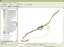
Development of Digital Property Parcel
Mapping and Related Attribute Data, Lake Ontario Shoreline – CJS was
responsible for the compilation and development of a digital property
parcel mapping database for the U.S. and Canadian shorelines of Lake
Ontario and the St. Lawrence River. Data was assembled from various
sources and where parcel data did not exist, it was created. Property
parcels were then attributed with a range of data including that related
to property value (assessment data), shore protection, dimensions and
shoreline geology. Data was then used in various models within the IJC
Lake Ontario – St. Lawrence River Water Level Study.
Download
Related Report
Development of a Revised Geomorphic,
Shore Protection and Nearshore Classification System for the Canadian and
U.S. Shorelines of Lake Ontario and the St. Lawrence River
Utilized various data sources to conduct a detailed
classification of shoreline attributes along the Lake Ontario and St.
Lawrence River for use in the IJC Lake Ontario - St. Lawrence River Water
Level Study.
Download
Related 2003 Canadian Coastal Conference Paper
Download
Full Consulting Report
Development of an Updated Kilometer-by-
Kilometer Lake Ontario - St. Lawrence River Historic Recession Rate
Database
Involved the collection, analysis and coordination of all
existing shoreline recession rate data for the Canadian and U.S.
shorelines of Lake Ontario and the St. Lawrence River and the incorporation of this data into GIS data bases
being used for the IJC Lake Ontario - St. Lawrence River Water Level
Study.
Download
Report
Review of Potential Data Sources for Use
in Evaluating Coastal Process and Riparian Impacts Associated With
Changing Water Levels on Lake Ontario and the St. Lawrence River
Provides a comprehensive review of a range of data,
reports, GIS data and other background information that is available for
use by the Coastal Working Group and others participating in the IJC Lake
Ontario - St. Lawrence River Water Level Regulation Study.
Download
Report
International Joint Commission Lake
Ontario – St. Lawrence River Water Level Regulation Study
Providing general technical, scientific and
administrative support to the Coastal Processes Working Group of the IJC
Study, whose key objective is to evaluate the impacts of various water
level regulation scenarios on coastal processes and the riparian interest
group.
Development of Continuous GIS Coverages for Shoreline Type,
Shoreline Protection, Nearshore Geology and Recession Rates, Lake
Erie Shoreline, Lower Great Lakes Erosion Study, U.S. Army Corps of Engineers -
Buffalo
District
Created continuous GIS coverages in Arc View
GIS format for a range of coastal zone data for the Pennsylvania and New
York shorelines of Lake Erie.
Download
Report
Review of Potential Data Sources for Use
in the Determination of Pre and Post-regulation Recession Rates on Lake
Ontario, Lower Great Lakes Erosion Study, U.S. Army Corps of Engineers -
Buffalo District
Reviewed various literature and GIS and aerial photographic
data sources that would be useful in conducting an analysis of historic
recession rates on Lake Ontario.
Download
Report
Development of a Revised Geomorphic,
Shore Protection and Nearshore Classification System for Lake Michigan,
U.S. Army Corps of Engineers - Detroit District
Utilized various data sources to conduct a detailed
classification of shoreline attributes along the Lake Michigan shoreline.
Detailed and summary statistics of classification types were prepared.
Download
Report (549KB)
Development of a Revised Geomorphic,
Shore Protection and Nearshore Classification System for the Lake Erie,
Lake Ontario, Niagara River and St. Lawrence River Shoreline, U.S. Army
Corps of Engineers - Buffalo District
Utilized various data sources to conduct a
detailed classification of shoreline attributes along portions of the
Great Lakes shoreline under the jurisdiction of the USACE Buffalo
District. Detailed and summary statistics of classification types were
prepared.
Download
Report (1.5MB)
Lake Michigan Potential Damages
Study,
U.S. Army Corps of Engineers - Detroit District, 1997-2001
Participating as a lead consultant in a
multi-year, multi-agency, multi-disciplinary investigation of erosion
processes, potential erosion damages and water level impacts of the
entire shoreline of Lake Michigan. Includes activities related to
classification of the shoreline, analysis and assessment of long-term
and short-term recession rates, land use and land use trend analysis,
and development of GIS and modeling applications.
Download
2000 Progress Report
Download
1999 Progress Report
Download
1996-1998 Progress Report
Participation in Lower Great Lakes Erosion
Study,
U.S. Army Corps of Engineers - Buffalo District, 1998-2001
Collection and Analysis of Coastal Zone Data,
Lake Erie and Ontario, U.S. Army Corps of Engineers - Buffalo District:
Compiled extensive database of natural resource, land use and physical
process data for U.S. Lake Erie and Ontario Shorelines and developed a
database management system in FoxPro to allow data analysis and query
generation. Database was linked to QuikView GIS for data visualization
and mapping purposes. Involved coordination and liaison with various
federal, state and municipal agencies and non-profit organizations.
1999 Canadian Coastal Conference,
Victoria BC
Organized and chaired the bi-annual conference of the
Canadian Coastal Science and Engineering Association. Involved 90
participants from across Canada and the United States, as well as a number
of international delegates. Organization activities included paper
scheduling and coordination, editing and assembly of conference
proceedings, accommodation, facility and meal coordination, budgeting,
preparation of announcements and advertising and other host activities.
Development of a Zambezi River Wetland
Information System, World Conservation Union (IUCN)
Assisted in the collection, compilation and analysis of a
range of natural resource information (maps, photos, videos, reports,
etc.) for input into an Internet and CD-ROM based Wetland Information
System for the Zambezi River basin in Southern Africa.
Ad-Hoc
Task Group, Incremental Approach to Lake Ontario Criteria Review,
International Joint Commission - Ottawa,
1999
Advised staff of
the IJC - a Canadian- U.S. agency - as well as staff of various U.S. and
Canadian government agencies as to the various data needs and database
structures required to properly evaluate and assess social, economic and
environmental impacts that might occur due to extreme high or extreme low
water levels on Lake Ontario that
may result as a result of man-made activities or from possible
climate change/variability scenarios.
Great Lakes Public Information Map of Shore Type,
Erosion and Accretion, U.S. Geological Survey
Assisted the U.S. Geological Survey, the U.S. Army Corps of
Engineers and the University of Virginia in the compilation of U.S. and
Canadian data for incorporation to a public information map on Great Lakes
shore type, erosion and accretion.
Copies Available - Please Write With Requests
Submersible Investigation of Glacial and Post-Glacial Geologic
Features, Fathom Five National Marine Park, 1996
Assisted researchers with the Geological Survey of
Canada (GSC), Parks Canada and
the Ontario Marine Heritage Committee in the observation and
interpretation of submerged geological features in Georgian Bay, Lake
Huron. This work was written up in the 70th Anniversary
Edition of Canadian Geographic Magazine (2000 Annual, Vol. 120,
No.1).
Copies Available - Please Write With Requests
Collection and analysis of Canadian Great Lakes shoreline
recession rate data, 1994-1995.
Collection and analysis of Canadian Great Lakes shoreline
recession rate data, 1994-1995.
Involved the collection of all existing shoreline recession
rate data for each of the five Great Lakes for delivery to the United
States Geological Survey and the University of Virgina for the
production of public information maps on erosion hazards.
The development of a comprehensive U.S. Great Lakes shoreline
recession rate data base, 1993-1994.
Involved the collection, analysis and coordination of all
existing shoreline recession rate data for each of the eight Great Lakes
States and the incorporation of this data into the GIS data base of the
U.S. Army Corps of Engineers.
Download
Report
An underwater geomorphological inventory,
Fathom Five National Marine Park, 1993.
Provided diving and professional services in order to
inventory, describe and interpret various underwater geomorphological
and geological features found within the boundaries of Fathom Five
National Marine Park.
Review and Synthesis of Geology, Physiography, Soils, Climate,
and Air Quality Information, West-Central Manitoba
Reviewed and summarized geologic and other information for
inclusion in the REPAP Manitoba Forest Management License Agreement 13
Year Operating Plan and Environmental Impact Statement.
Review and Synthesis of Geology, Physiography, Soils, and
Biomatic Information, City of Mississauga Natural Areas Study
Reviewed and summarized geologic and other information for
inclusion in a comprehensive inventory and assessment of all natural
areas within the City of Mississauga, Ontario.
Coastal Processes Study and Breakwater Impact Assessment,
Jackson's Point, Lake Simcoe
Utilized wave refraction modeling to determine potential
impacts of a proposed marina breakwater on coastal processes and
adjacent shorelines.
A literature review of studies on the recreational &
developmental carrying capacity of coastal zones, 1993.
Conducted a literature review to determine the nature and
extent of research conducted on the topic of recreational carrying
capacity, specifically as it applies to development and recreation in
coastal environments.
Download
Report (240KB)
The development of a Great Lakes - St. Lawrence River
Emergency Action Plan for flooding, 1993.
Prepared a document describing the roles and
responsibilities of federal and provincial agencies in a Great Lakes -
St. Lawrence River flooding emergency and described crisis response
measures to be put in effect at certain water level stages.
The development of a Great
Lakes - St. Lawrence River shoreline classification system,
1993.
Developed and refined a shoreline classification scheme for
the Great Lakes shoreline and administered the application of this
scheme to the shoreline in order to map and identify the frequency and
distribution of various shore types throughout the basin.
An erosion sensitivity evaluation of Great Lakes shore types
to changes in water levels, 1993.
Supervised the application of a numerical cross-shore
profiling model to determine potential changes in recession rates of
various Great Lakes shoreline types with changes in water level regimes.
An inventory and assessment of shoreline management policies
in the Great Lakes basin, 1993.
Co-ordinated a bi-national effort to inventory and assess
specific shoreline management practices in place throughout the Great
Lakes basin, including the provision of information on the impacts of
these practices on various interest groups and the natural environment.
An inventory of crisis responses to extreme water level and
flood events in the Great Lakes, 1993.
Completed an inventory and assessment of specific landside
crisis responses to extreme water level fluctuations, including
information on their extent, effectiveness and costs. Such measures
included emergency response plans, storm forecasting networks and
various low or high water assistance programs.
GIS
and Database Services
Development of Geomorphic,
Shore Protection and Nearshore Classification GIS Data for the Canadian
and U.S. Shorelines of Lake Ontario and the St. Lawrence River
Utilized various data sources to conduct a detailed
classification of shoreline attributes along the Lake Ontario and St.
Lawrence River for use in the IJC Lake Ontario - St. Lawrence River Water
Level Study. Various GIS mapping coverages were produced for shoreline
geology, shore protection, nearshore geology, and land use.
Download
Related 2003 Canadian Coastal Conference Paper
Download
Full Consulting Report
Development of Information Management Strategy for the
IJC Lake Ontario - St. Lawrence River Water Level Study
Assisted with the development of an Information Management Implementation
Strategy for the ongoing International Joint Commission Lake Ontario - St.
Lawrence River Water Level Study. The work was carried out in support of
the Common Data Needs Technical Working Group within the Study and
involved an inventory of existing geospatial data and metadata, the
conduction of a user needs assessment of all the task groups within the
study and the development of comprehensive information management
solutions and recommendations.
Mapping
and Classification of Shoreline Protection Structures and Recreational
Boating Facilities, U.S. Army Corps of Engineers - Detroit District
Utilized air photo and video analysis to
classify and map shoreline protection structures in four drowned river
mouth areas along the Lake Michigan shoreline in Michigan and Wisconsin.
Mapping was completed in Arc View GIS format.
Download
Report (6.6MB)
Development of Continuous GIS Coverages for Shoreline Type,
Shoreline Protection, Nearshore Geology and Recession Rates, Lake
Michigan Shoreline, U.S. Army Corps of Engineers - Detroit
District
Created continuous GIS coverages in Arc View
GIS format for a range of coastal zone data for Lake Michigan shorelines
in Ottawa and Allegan County, Michigan and Sheboygan, Ozaukee and
Manitowoc Counties in Wisconsin.
Download
Report (9.6MB)
Detailed
Mapping and Classification of Shoreline Protection Structures and
Historical Trends, Lake Michigan Shoreline, U.S. Army Corps of Engineers -
Detroit District
Completed detailed mapping of open coast shore
protection structures in place along the Lake Michigan shoreline in Ottawa
and Allegan County Michigan and Sheboygan, Ozaukee and Manitowoc Counties
in Wisconsin. Analysis of the changes in shore protection over the past
ten years was completed. Mapping of structures was completed in Arc View
GIS format.
Download
Report (481KB)
Collection and Analysis of Coastal Zone Data, Lake
Erie and Ontario, U.S. Army Corps of Engineers - Buffalo District
Compiled extensive database of natural
resource, land use and physical process data for U.S. Lake Erie and
Ontario Shorelines and developed a database management system in FoxPro
to allow data analysis and query generation. Database was linked to
QuikView GIS for data visualization and mapping purposes. Involved
coordination and liaison with various federal, state and municipal
agencies and non-profit organizations.
Download
Report (2.1MB)
Development
of Recession Rate Analysis System, U.S. Army Corps of Engineers -
Detroit District
Compiled extensive
database of natural resource, land use and physical process data for
Lake Michigan Shoreline and developed a database management system in
FoxPro to allow data analysis and query generation.
Database was linked to QuikView GIS for data visualization and
mapping purposes.
Download
Related 1999 Canadian Coastal Conference Paper (3.4MB)
Development of GIS Project Management Guidelines, Prince Rupert
Forest District, British Columbia Ministry of Forests
Assisted with the preparation of guidebooks for GIS project
management and completion for the Land Information Management Section of
the Prince Rupert Forest District.
Data Service Centre Implementation Project
Communication Activities, British Columbia Ministry of Forests
Responsible for the provision of all internal and external
Ministry communications related to the DSCIP project, a major GIS and
geomatics restructuring and reorganizational activity throughout all MOF
regions and districts within the Province. Activities include newsletter
and journal article preparation, WWW page development and maintenance,
preparation of Ministerial briefings, preparation of presentations and
other internal MOF communication documents. Involved management and
coordination of various activities in all MOF regions and districts of
British Columbia.
GIS Strategic Plan Development, City of Victoria,
British Columbia
Assisted the City of Victoria to develop the City's GIS
Strategic Plan. This project evaluated the historical and current use of
GIS within each department of the City and the future expectations for
GIS.